Batanes, officially the Province of Batanes, is an archipelagic province in the Philippines, administratively part of the Cagayan Valley region. It is the northernmost province in the Philippines, and the smallest, both in population and land area. The capital is Basco, located on the island of Batan.
The island group is located approximately 162 kilometres (101 mi) north of the Luzon mainland and about 190 kilometres (120 miles) south of Taiwan (Pingtung County), separated from the Babuyan Islands of Cagayan Province by the Balintang Channel, and from Taiwan by the Bashi Channel.
The name Batanes is a hispanicised plural form derived from the Ivatan endonym Batan.
The province has a total area of 219.01 square kilometres (84.56 sq mi) comprising ten islands situated within the Luzon Strait between the Balintang Channel and Taiwan. The islands are sparsely populated and subject to frequent typhoons. The three largest islands, Batan, Itbayat, and Sabtang, are the only inhabited islands.
The northernmost island in the province, also the northernmost land in the entire Philippines, is Mavulis (or Y'ami) Island. Other islands in the chain are Misanga (or North), Ditarem, Siayan, Diogo (or Dinem), Ivuhos, and Dequey. The islands are part of the Luzon Volcanic Arc.
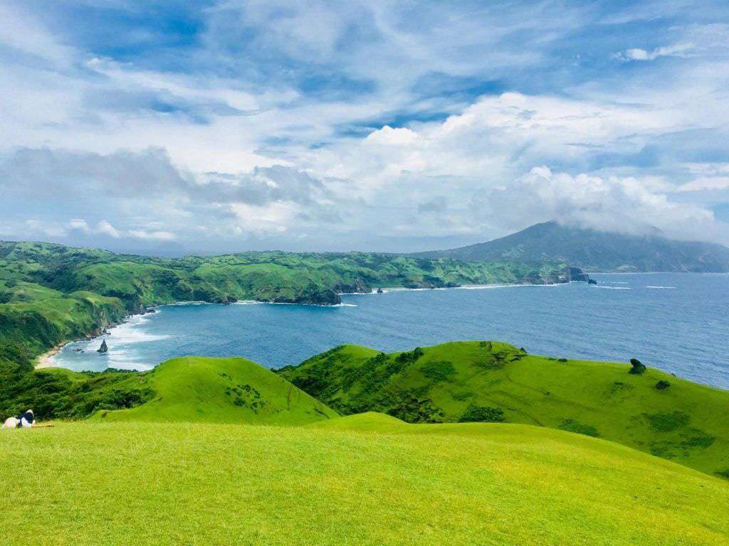
Almost one-half of Batanes is hills and mountains. Batan Island is generally mountainous on the north and southeast. It has a basin in the interior. Itbayat Island slopes gradually to the west, being mountainous and hilly along its northern, eastern coast. On Sabtang, mountains cover the central part, making the island slope outward to the coast.
The ancestors of today's Ivatans descended from Austronesians who migrated to the islands 4,000 years ago during the Neolithic period. They lived in fortified mountain areas called idjangs and drank sugar-cane wine, or palek. They used gold as currency and were farmers. They were seafarers and boat-builders. Batanes was a major site for the Maritime Jade Road, one of the most extensive sea-based trade networks of a single geological material in the prehistoric world, operating for 3,000 years from 2000 BCE to 1000 CE.
In 1687, a crew of English freebooters headed by explorer, pirate, and naturalist William Dampier came with a Dutch crew and named the islands in honour of prominent Dutch and British figures. Itbayat was named "Orange Isle" after William of Orange. Batan was named "Grafton Isle" after Henry FitzRoy, 1st Duke of Grafton. Sabtang Isle was named "Monmouth Isle" after James Scott, 1st Duke of Monmouth. Capt. Dampier stayed for less than three months, and did not claim the islands for the British crown.
In 1783, the Spanish claimed Batanes as part of the Philippines under the rule of Governor-General José Basco y Vargas. Batanes was ruled as part of the Provincia de Cagayan. The Bashi Channel was increasingly used by English East India Company ships and the Spanish authorities brought the islands under their direct administration to prevent them falling under British control. The Ivatan remained on their idjang castle-fortresses for some time. In 1790, Governor Guerrero decreed that Ivatans were to live in the lowlands and leave their remote idjang. The mangpus, or indigenous Ivatan leaders, headed by the Ivatan hero Aman Dangat, revolted against the Spanish invaders.
Using guns, the Spanish ended the revolution, killing Aman Dangat and several other Ivatan leaders. Basco and Ivana were the first towns established under full Spanish control. Mahatao was then administered by Basco, while Uyugan and Sabtang, by Ivana. Itbayat was not organized until the 1850s, its coast being a ridge. Soon, Ilocanos came to the islands and integrated with the local population.
Roads, ports, bridges, churches and government buildings were built in this time. Limestone technology used by the Spanish spread to the islands, making bridges strong and fortified. Some of these bridges still remain at Ivana and Mahatao. By 1890, many Ivatans were in Manila, and became ilustrados, who then brought home with them the revolutionary ideas of the Katipunan. These Ivatans, who were then discontented with Spanish rule, killed the ruling General Fortea and declared the end of Spanish rule.
oward the end of the Spanish administration, Batanes was made a part of Cagayan. Due to historical reasons from that time, some segments of Taiwan society argue that the islands should not belong to the Philippines. In 1909, the new American authorities organized it into an independent province, upon the approval of Act No. 1952. During the American colonial period, additional public schools were constructed and more Ivatan became aware of their place in the Philippines.
In 1920, the first wireless telegraph was installed, followed by an airfield in 1930. New roads were constructed and the Batanes High School was instituted.
Because of their strategic location, the islands was one of the first points occupied by invading Japanese imperial forces at the outbreak of the Pacific War. The morning of December 8, 1941, the Batan Task Force from Taiwan landed on the Batan Islands, which became the first American territory occupied by the Japanese. The purpose of the invasion was to secure the existing small airfield outside Basco, which was accomplished without resistance. Japanese fighters from Basco took part in the raid on Clark Air Base the following day. Over the next several days, the success of the Japanese bombing of Clark Field rendered a base at Basco unnecessary, and on December 10, 1941, the naval combat force was withdrawn to participate in the invasion of Camiguin.
As part of an administrative reorganization, the province of Batanes was downgraded into a municipality of Cagayan from 1942 to 1944. Upon its restoration, Victor de Padua, an Ilocano who was one of the first School Superintendents on Batan was made Provincial Governor. Early in 1945 the island was liberated by the Philippine Commonwealth forces of the 1st and 12th Infantry Division of the Philippine Commonwealth Army.